|
General
Island name: Sint Eustatius
Country: Netherland Antilles (NT).
Nationality: Dutch Antillean.
Language: Dutch (official), English.
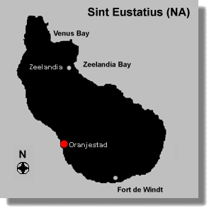
Capital: Oranjestad.
Population: 3,300.
Climate: Generally dry and sunny. Light constant northeast trade
winds bring constant cool breezes and sufficient moisture to keep the average
daytime temperature down to about 27 degrees Celsius. The average night
temperature drops to a comfortable 23 degrees. Rainfall occurs in showers
of medium duration during the months of April, June and September.
Geography
Area: 30.6 sq km (11.8 sq miles).
Coastline: Statia is surrounded by coral reefs.
Geographic coordinates: 17ş 49' N, 62ş 98' W.
Highest point: Mt. Mazinga, 602 m (1,968 ft).
Location: North Eastern Caribbean, 240 km east of Puerto Rico,
144 km east of St. Croix, 61 km south of St. Maarten and 27 km southeast
of Saba.
Size: 8 km (5 miles) long and 3.2 km (2 miles) wide.
Terrain: The island is saddle-shaped and has a rugged scenery.
Tourist Information
Accommodations: There are no resorts or large hotels on St Eustatius,
only a few small hotels, inns and guest houses.
Activities: Diving, sailing, cruising, fishing, hiking.
Average tourist arrivals: 4,025 (2009).
Crime: The island is very peaceful, there are no safety problems.
Electricity: The voltage is 110 A.C. 60 cycles. 220 voltage A.C.
will not work without a transformer. Plugs tend to be two flat prongs.
Entry Requirements: A valid passport is the entry requirement
for visitors to St. Eustatius including USA and Canadian citizens. Birth
Certificates and drivers licenses are no longer accepted. Citizens of some
countries in the world do need a visa for their entry to St. Eustatius.
Extension of stay: you can ask for an additional 3-month extension.
Telephone: County code plus local area code is +599-41.
Time: GMT/UTC -4.
Money
Cost of living: high.
Credit cards: Traveler's checks and credit cards are widely accepted,
though American Express and Diners Club are not as popular as Visa and
MasterCard, while Discover is gaining popularity.
Currency: Netherlands Antillean florin (NAf). The U.S. dollar
is as widely accepted as the local currency. The exchange rate is 1.78
florins to US$1 (NAf 1 = 56˘).
Tipping: Some restaurants add a 10% to 15% service charge automatically.
Tip taxi drivers and dive masters 10 %.
Air Transport
Airport: FD Roosevelt (EUX), located 1km (0.6 miles) from Oranjestad
(Telephone: (599-3) 18-2887).
Departure Tax: US$ 12.00 for international and US$ 5.65 for local
destinations within the Dutch Caribbean.
Flight Times: St. Maarten 15 minutes.
Water Transport
Ferry Service: There is no scheduled boat or ferry service to
Statia.
Ports and harbors: All cruise ships anchor out and use tenders
to bring their cruise passengers to shore.
Politics
Ethnic groups: mixed black 85%, other 15% (includes Carib Amerindian,
white, East Asian.
Government type: parliamentary. Bonaire is an autonomous country
within the Kingdom of the Netherlands; full autonomy in internal affairs
granted in 1954; Dutch Government responsible for defense and foreign affairs.
Legal system: based on Dutch civil law system with some English
common law influence.
Literacy: 96.7 %.
Religions: Roman Catholic 72 %, Pentecostal 4.9 %, Protestant
3.5 %, Seventh-Day Adventist 3.1 %, Methodist 2.9 %, Jehovah's Witnesses
1.7 %, other Christian 4.2 %, Jewish 1.3 %, other or unspecified 1.2 %,
none 5.2 %.
Economy
Agriculture-products: Poor soils and inadequate water supplies
hamper the development of agriculture.
GDP per capita: US$ 16,000.
Industries: tourism, salt extraction.
Natural resources: salt.
Unemployment rate: 17.0 %. |