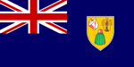
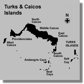
|
General
Country: Turks & Caicos Islands (TCI, overseas territory
of the UK).
Nationality: none.
Language: English (official).
Islands Capital: Grand Turk (Cockburn Town).
Population: 21,746 (July 2007 est.).
Climate: tropical; marine; moderated by trade winds; sunny and
relatively dry.
Geography
Area: 430 sq km.
Coastline: 389 km.
Geographic coordinates: 21 45 N, 71 35 W.
Highest point: Blue Hills 49 m.
Location: Caribbean, two island groups in the North Atlantic
Ocean, southeast of The Bahamas, north of Haiti.
Terrain: low, flat limestone; extensive marshes and mangrove
swamps.
Tourist Information
Overview: The name Turks came from the Turks cactus, and the
name Caicos means cays. These islands are an archipelago of 40 islands
and cays with phantastic white sandy beaches and crystal clear turquoise
waters. Only 8 of the 40 islands are inhabited: Salt Cay, Grand Turk, South
Caicos, Middle Caicos, North Caicos, Providenciales, Parrot Cay and Pine
Cay. Diving in the islands is excellent thanks to several hundred miles
of coral reef. Just off-shore in 35 feet of water is a "forest" of black
coral chock-full of brilliantly-colored coral and marine life. There are
numerous national parks, nature preserves, sanctuaries and historical sites
on the islands. Despite the fact that tourism is the islands' main industry,
the islands remain largely uncommercialized and unspoilt.
Accommodations: ranging from small family run hotels and cozy
bed & breakfasts to luxurious waterfront villas and all inclusive resorts.
Activities: Swimming, snorkeling, scuba diving, windsurfing,
deep sea fishing, golf, horseback riding. parasailing, sailing, skydiving,
tennis. Annual underwater photographic competition in May and October.
Electricity: 110 volts at 60 cycles, American-style plugs.
Entry Requirements: All visitors must hold a return or onward
ticket, all documents required for their next destination and sufficient
funds. British passport holders do not require visas to enter Turks and
Caicos Islands. Visitors from the US and Canada will only need to show
proof of citizenship: either a valid passport, or an expired passport no
more than five years, or an original birth certificate and official photo
identification, such as a driver's license. Visitors from other countries
do require passports, but no visas are necessary except from countries
of the former Eastern Bloc.
Safety: Most visits to the Turks and Caicos Islands are trouble-free.
But you should nonetheless take sensible precautions against petty crime.
Telephone: the international: country code is 1-649.
Time: UTC-5, daylight saving time: +1hr, begins first Sunday
in April; ends last Sunday in October.
Money
Currency: US dollar (USD).
Credit cards: Traveler's checks and major credit cards are accepted
in most shops.
Tipping and Taxes: Room tax: 8 %. Service charge: 10 % at resorts.
A government tax of US$ 15.00 is levied on each car rental, and US$ 8.00
on scooter rentals.
Air Transport
Airport: Providenciales International Airport (PLS); 2 km W of
Providenciales town. Grand Turk International (GDT), 3 km (2 miles) SE
of Cockburn town. Getting between the islands is easiest by plane. All
the islands except West and East Caicos are served by air from Grand Turk
and Provo. Sky King, InterIsland Airways and Turks & Caicos Airways
fly between the islands on a quasi-scheduled basis.
Departure Tax: Visitors must pay a departure tax of US$ 35.00
on all international flights when 12 years of age and older.
Flight Times: London 12 hours; Miami 2 hours.
Land Transport
Public Transport: There are no public buses on any of the islands,
so taxis are the best all-around transport option. Taxy fares are negotiateble.
Cars and motorcycles can be rented on Provo and Grand Turk only. Driving
is on the left hand side of the road. Valid license required for use up
to three months by US and Canadian citizens as well as citizens of Commonwealth
and Caribbean countries. All other nationalities must receive prior approval
from the Traffic Department for temporary use of vehicle.
Water Transport
Ports and harbors: Grand Turk, Providenciales. Yachts can clear
customs at marinas on Provo, South Caicos and Grand Turk.
Ferries: The ferry Caicos Express operates sporadically between
Provo and Sandy Point on North Caicos. It stops en route by request at
Pine Cay, Parrot Cay and Middle Caicos. Salt Cay Charters runs a bi-weekly
ferry service between Salt Cay and Grand Turk..
Politics
Government type: British Overseas Territory with Internal Self-Government.
Ethnic groups: black 90 %, mixed, European, or North American
10 %.
Legal system: based on laws of England and Wales, with a few
adopted from Jamaica and The Bahamas.
Literacy: total population: 98 % (male: 99 %, female: 98 %).
Religions: Baptist 40 %, Anglican 18 %, Methodist 16 %, Church
of God 12 %, other 14 % (1990).
Economy
Agriculture-products: corn, beans, cassava (tapioca), citrus
fruits; fish.
GDP per capita: US$ 11,500 (2002 est.).
Industries: tourism, offshore financial services.
Natural resources: spiny lobster, conch.
Unemployment rate: 10 % (1997 est.). |